Menu

Dominion Pipeline Monitoring Coalition

FB ICON 2Share current page:   facebooktwittermail  
Shenandoah Mountain: George Washington National Forest

Primary menu

Skip to primary content
Skip to secondary content
  • Dominion Pipeline Monitoring Coalition
  • Allegheny-Blue Ridge Alliance
  • Environmental Review
  • Pipeline Air Force

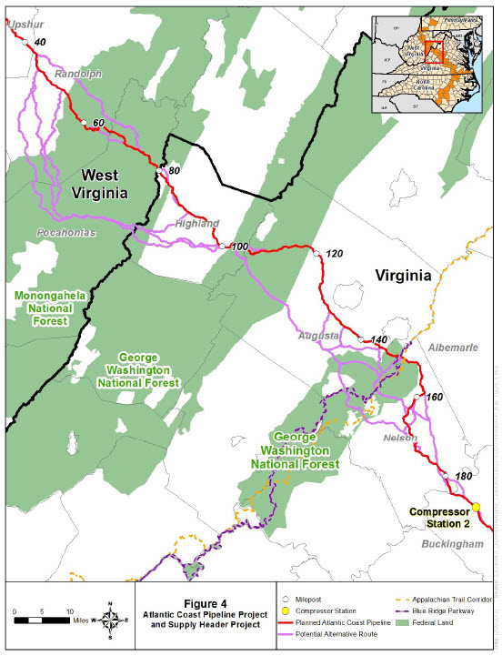
FERC Scoping Notice: Alternate Routes

Posted on March 23, 2015 by Rick Webb

From FERC Scoping Notice (02/28/15)
FERC Project Map

Environmental Mapping System

INTERACTIVE WEB MAP : Current Version 
Users Guide to the ACP-EMS
Presentation on Map Development, 02/05/16
Cow Knob Salamander Page

Project Maps

  • Atlantic Coast Pipeline Overview Map
  • Atlantic Coast Pipeline Interactive Parcel Map
  • Atlantic Coast Pipeline County Parcel Maps
  • FERC Scoping Notice: Alternate Routes
  • Dominion’s Submitted Alternatives

Request for Detailed GIS Data Layers

The Dominion Pipeline Monitoring Coalition (DPMC) has asked the Federal Energy Regulatory Commission (FERC) to specifically identify and provide detailed maps of the alternate pipeline routes that will be considered during the National Environmental Policy Act review process. Conflicting information has been provided to the public, and it is unclear which of multiple alternate routes will actually be considered in the review process. The DPMC has also asked for a delay or re-initiation of the comment period on environmental issues until after detailed GIS data layers for the alternate pipeline routes have been made available.

". . . meaningful implementation the National Environmental Policy Act depends on informed input from all interested and concerned stakeholders, which in turn is dependent on timely access to fundamental project information."

- DPMC submission to FERC, 03/08/15

  • Dominion Pipeline Monitoring Coalition
  • Allegheny-Blue Ridge Alliance
  • Environmental Review
  • Pipeline Air Force